 Live Music Archive
 Librivox Free Audio
 Metropolitan Museum
 Cleveland Museum of Art
 Internet Arcade
 Console Living Room
 Books to Borrow
 Open Library
 TV News
 Understanding 9/11
tv News4 at 5 NBC October 29, 2012 5:00pm-6:00pm EDT
5:00 pm

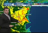
right now at 5:00, the eye of the storm is coming ashore right now. hurricane sandy pounding the eastern seaboard, roads are flooding, trees are down, and folks, we still have hours to go. thanks for staying with us for continuing storm team 4 coverage. >> this storm is as predicted, intensifying at this hour. the fierce storm is whipping up waves along the shoreline at rehoboth beach, delaware. our coverage begins with chief meteorologist doug kammerer. this storm seems to be right on schedule. >> it really does. it is now moving close to 30 miles an hour. it has made a beeline for the jersey coast. it is now just to the north and
5:01 pm
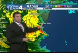
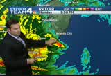
coming ashore. you can see what's going on. a ton of rain on the west side of the storm. but notice, the strongest side, normally the northeast corner here, that's where you see the strongest winds, 84-mile-an-hour wind gusts in long island. notice the rain here, really cutting off on the back side, as it makes its way in. we'll continue to see rain here, though, as we continue to be on the southwest side of the storm. here's atlantic city. here's the ey coming onshower right now. atlantic city, probably seeing the strongest winds they have seen in years. maybe even decades right now. potentially 90, 100-mile-an-hour winds with this storm. you can see the outer eye wall which is right here through cape may county, new jersey, along the delaware bay. we're watching this rig around rehoboth beach. they're probably seeing very strong winds out of the northwest right now. once again, they could easily being seeing 60, 70, 80, 90-mile-an-hour winds even towards rehoboth beach. we are just getting started.
5:02 pm
i think with some of the strongest winds in our area. you can see how theaves have been coming on. these are the bands that you'll continue to see. you'll look outside and say, it's not raining too hard. five minutes later here comes a band bringing heavy rainfall, and it will bring you very heavy wind as well. the winds will continue to gust throughout the afternoon. and they're gusting now over tropical storm force. and they have been for the last couple of hours. let's take a couple of zooms here and you can see around annapolis, toward baltimore, here's another band making its way through anne arundel county, and down to the south, fairly heavy rain along the northern neck. you folks are really getting hammered during the afternoon today and back towards winchester, where we have fairly heavy rain continuing to fall. of course, we have the snow back to the west in through the mountains. how about the rain so far today. some areas have seen five to ten inches of rain along the chesapeake, pax river, almost
5:03 pm
four inches of rain. nearly two and a half inches near martinsburg. a little less down to the south. we're starting to see those totals on the increase, too. winds gusting to 52 miles an hour now in washington, 54 in camp springs, and up towards mar sinsburg 46. once again, 39 miles an hour is tropical storm force. we've seen those for the last couple of hours. we'll continue to see those, most likely for the next 12 hours. i think we'll increase these numbers, potentially 60, 70, maybe 80 miles an hour. that's why we have that high wind warning in effect. that's why we will be here with you all night long right here on nbc 4. of course, storm team 4 has you covered. >> doug, we know you do. thank you, sir. heavy rain and strong winds are slamming the coastlines right now. >> slamming is a good word. wendy rieger is riding it out. she's in rehoboth beach, delaware. wendy, what's it looking like now?
5:04 pm
>> reporter: it's interesting how they come -- we're sitting here for the last hour, yeah, there's just waves on the beach, and bam, i mean, three minutes ago, wham, they started up again with those beautiful hawaiian style waves where you get this nice front, a smooth front and a beautiful curl. looks like we have another group coming off in the distance where i can see, where it really catches your attention. i've been in a lot of hurricanes, i've never seen quite with this fingerprint before, where it -- see, here goes one series. that really nice kind of curl, and then look at this coming up right behind it. let's take a moment to look at this. look at what that is producing. wow! cameraman jay alby was out earlier, again, it's interesting, one side of the building might be feeling one thing, on the other side might be feeling something else. let's look at the video he
5:05 pm
captured for us. again, i think people who live here, and are living in different parts of rehoboth will tell you they're having different experiences at different times of the day. on the western side over there near the bay, the winds start whipping around one way. the bay has been up -- in dewey has been up in the street all afternoon. it has been a bit of a mess over there. while everything was pretty calm here. so it's going to be interesting in the next, you know, hour. this is organic to watch this unfold. and see the personality and character of this meteorological event. so far, not hearing of damage. the only flooding is over on the other side. that's a couple of people, you saw maybe two cars. but it came up to about my knees. and that was -- i just heard something go clang. it wasn't anything. so here we are. and we're going to be here all afternoon. we'll be right here keeping an eye on it for you and letting you know how this thing
5:06 pm

progresses. back to you. >> awesome pictures there. high tide is coming up about 8:25. that is certainly something to keep an eye on. the trees have been coming down. we've been getting reports all afternoon for a couple of hours now. falling trees, of course, can be very dangerous for drivers. a large tree took down power lines as it fell on a road in falls church this afternoon. >> shomari stone is live with damage to show us. >> reporter: right now, we're here in arlington, and yes, you can see this tree fell down, i'd say around 30 minutes ago. we're on the 4100 block of glebe road. drivers are trying to avoid it. this is why emergency officials are telling you to stay inside, avoid being outside. that wind just came right through here, and as my photograph zooms in right over there, you can see on the slope where it's unearthed and the tree came right across the road, come over here, you guys, you
5:07 pm

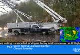
can see this gentleman. first of all, what's your name? >> i'm tim. how are you? >> tim, how is it going? >> good. >> i see you're out here. why are you driving around and how does it feel to see that tree right there? >> looking around for a lot of stuff. both mitch and i work with the environmental group greenpeace and we're worried about these events coming up more and more. we'll see more flooding, more severe weather, more things take a toll. we've got to find a way to get renewable energy. >> i understand your politics. good luck to you. just make sure you're careful on the road as i'm sure you can understand. you guys be careful. basically this guy, i guess he's with greenpeace and he's driving around figuring something out about global warming. so right over here, make sure when you're out, that you make sure that you stay away from these trees. back to you in the studio, guys. >> sho mami, thanks so much. >> schools across the washington area announced closures for tomorrow. in virginia, public schools in
5:08 pm

anne arundel, arlington, calvert, charles, culpepper county all closed tomorrow. schools in fauquier, fairfax, loudoun and alexandria and falls church closed tomorrow. no classes. in maryland, howard, montgomery, prince william, st. mary's, prince george's county schools all closed tomorrow. lastly, d.c. public schools will be closed. >> those who live along the chesapeake bay are keeping an extra close eye out for sandy. >> news4's derrick ward spent this day in chesapeake beach and he talked to folks who say they're ready for whatever the storm throws their way. >> reporter: it's obvious when you live in a place that has the word beach in its name, you get used to weathering storms. >> been here for 30 years. >> we're tough down here in southern maryland, that's all i can say. >> reporter: that doesn't mean
5:09 pm

you don't take all the prudent precautions, like gassing up. >> all good. it comes with the turf. >> reporter: it does mean you keep an eye on things even when you live on high ground. >> i'm coming down to make sure it's not doing damage to my place of business, you know. >> reporter: yes, the bingo parlor sandbag and dry for now. the halloween getup said she's keeping it light, but she's very serious about one thing, and that's not taking a massive storm too lightly. >> we got the radios and things. if i hear it, if i hear evacuate, i'm gone. >> reporter: the same holds true in neighboring north beach. by early afternoon, it started to look like a storm proper. and they started closing some streets off in anticipation of flooding. >> and with the wind coming in closer to north beach, it's going to push the water up the bay rather than out. that's going to make a great difference here. >> reporter: the hope is that difference doesn't amount to too much damage. in calvert county, derrick ward,
5:10 pm
news4. >> and we are just getting started here on news4 at 5:00 tonight. storm team 4 coverage of hurricane sandy continues in prince george's county right after the break. >> and it is snowing, snow has begun to fall in the mountains of west virginia. and this is just the beginning. >> and doug's still tracking the storm. he just stepped outside. >> we're going to continue to watch as sandy makes its way inland across our region. we'll talk much more about that coming up in just a minute.


5:13 pm

we are continuing our live team coverage. there you see the picture here in the nation's capital. you can barely see the washington monument. these are live pictures right now as sandy slams ashore on the
5:14 pm
east coast. the winds are really picking up out there. the rains have intensified. and if you step outside, you can really feel it. >> it is thick out there. pat collins is keeping track of the storm's effects on montgomery county right now. >> he's located on i-270 in rockville now to tell us what he's seeing up there. pat? >> reporter: this is the time, i think, to get serious. the rain is picking up. the winds are picking up. this is the time to stay home. this is not a time to go out and get something. if you don't have it now, live without it. stay home. let this storm pass. now, we're on 270 near montrose road exit. you can see out here the traffic is very light. the rain is coming down. cars are moving at a speed limit pace. if you use 270 for your daily commute, you can see this is a dramatic change to what you normally see on a week day night. further down 270 is montrose
5:15 pm

road, and down montrose road is a street where we went into earlier today, a tree that came down across the road into a wire and then on top of a woman's car. it was a large oak tree. fortunately, no one was hurt. just the car. neighbors came in to remove the tree. they had that lane pretty much opened up within a half an hour. and a short time after that, pepco moved into that street to work on the downed wires and restore power there. it is likely this scene will be repeated over and over again as we go through the night. all-important information for you to remember. remember to stay home. stay out of the storm. don't go out. live with what you have. and just keep an eye on everyone in your house. for now, i'm live. montgomery county. now back to you. >> best advice out there, pat collins.
5:16 pm
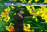
pat, thank you. >> we've been in place talking about this all afternoon, all day. and now right on schedule, this is really intensifying, hitting us hard. >> we were talking yesterday between 5:00 in the afternoon and 5:00 tomorrow morning, this is the critical time. the winds gusting over 50 miles an hour. you want to make sure, just as pat said, good advice, if you're inside your house right now, this is where you need to stay. you need to continue to charge your phone, and if power goes out that you have everything around you that's available. we're seeing more power outages and more trees down. let's show you how things are out at the airport. it is simply nasty out there right now. and it's going to continue to be over the next couple of hours. once again, the storm making its way onshore, up there toward portions of new jersey. but this is not going to let up for us anytime soon. as of 5:00, the latest advisory still has max winds of 90 miles per hour. once again, this is very close to making its way onshore. if it's not already doing so.
5:17 pm
you can see the extent of this storm, from all the way back in towards central canada, that is where these clouds are. central canada. and if you follow these all the way out into the atlantic, you're going way past bermuda. this has huge, huge implications on a lot of people from rain, from wind, to flooding, to blizzard conditions. we're seeing blizzard conditions just about 100 miles away. let's take you closer in. here's atlantic city, new jersey, saulsbury, and rehoboth, they're really seeing strong winds right now. it is this band right here, this is the eye wall that you can see. but one thing i want you to notice, look at the drying coming in here. this is not rain, this is dry air that's wrapping around the system. so the rain just shutting off right now around atlantic city, around philadelphia. good news for them. but notice where all the rain is, to the south and west of the eye, and that, of course, is where we are. we continue to see the rain coming through. we continue to see these bands, there's another one right here
5:18 pm
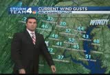
that just came through portions of anne arundel county, and prince george's county, around laurel and through the district in about the next 15, 20 minutes. we'll see higher wind gusts with that. current wind gusts, 54 miles an hour out at the airport. towards the beltsville area, buoy and crofton, westmoreland county, you folks are all seeing that very heavy rain. right now with the winds, 37-mile-an-hour winds in gaithersburg, 52 at airport, 51 in pax river. once again, we can expect these to climb as we move through the next couple of hours as sandy gets closer. the rest of today, around 6:00, the rain continuing to increase. the winds continue to increase, 40 to 50 miles an hour with higher guests. heavier rain at 6:00. we continue to see the heavy rain and damaging wind right on through the midnight hour. what about tomorrow. the storm system making its way in. actually, coming closer to us. but that doesn't really matter too much.
5:19 pm
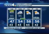
it's going to be stalling and slowing down. so we'll stay with the rain. the winds will calm down as the system begins to decrease in intensity. showers continue. but not too heavy. it will be chilly and breezy tomorrow. 5:00 in the afternoon, much less wind with rain, but most of that will be light and scattered. we may have to throw in some snow in and around the d.c. metro area. but don't worry, it will not cause any problems, but just something that this storm brings us as we make our way through the next couple of days. 54 on halloween. we'll see a chance for showers on halloween. thursday, friday, saturday and sunday, below average. but dry. we will be able to clean up after this storm. we're going to need it as we're going to be in this for the next 12 hours or so. you want to stay right here with nbc 4. we're streaming online at nbcwashington.com. download our apps. there are so many ways to stay informed here at nbc. >> you noticed the wind more than the rain right now. >> i stepped outside and you heard it as soon as you stepped
5:20 pm

outside. the flag out front is blowing, the trees are blowing around. again, we're going to see a lot of trees down. please stay indoors. >> thanks, doug. >> stay right there. we have new developments and continuing coverage. we've got power outages, and sandy interrupts the political campaign. >> do not delay, don't pause, don't question the instructions that are being given. >> sandy is another devastating hurricane by all accounts. and a lot of people are going to be facing some real tough times. anncr: seven-hundred-thousand jobs.
5:21 pm

that's what the plan george allen supports... would cost our economy. newspapers called it "economically destructive." like allen's votes to give tax breaks to companies... that ship jobs overseas, his economic plan would... help big corporations, devastating the middle class. allen even voted against tax breaks for small businesses. virginia can't afford to go back to george allen. the democratic senatorial campaign committee... is responsible for the content of this advertising.
5:22 pm

we were told to build a 30-foot stage. gathered the guys and we built that 30-foot stage, not knowing what it was for. just days later, all three shifts were told to assemble in the warehouse. a group of people walked out on that stage and told us that the plant is now closed and all of you are fired...
5:23 pm

i looked both ways, i looked at the crowd, and...we all just lost our jobs. we don't have an income. mitt romney made over 100 million dollars by shutting down our plant and devastated our lives. turns out that when we built that stage, it was like building my own coffin, and it just made me sick. [ male announcer ] priorities usa action is responsible for the content of this advertising. we are back now, and take a
5:24 pm

look at this. this is the shore, the beach, and rehoboth, delaware, where wendy rieger has been covering this storm all day live. these waves are really kicking it up there. we saw ten-foot waves rolling in about an hour ago. and now you can see these monster waves slamming ashore there in rehoboth. >> and massive flooding on the city streets there, and to the south. and dewey, as wendy showed us, and team rehoboth all over the area there. high winds are knocking out power across our region right now. >> news4's keith russell is live in the newsroom with the latest op the power outages. >> the latest, pat, is at times the numbers have teetered. well, now they are certainly going up. let's start with pepco. at least 13,000 customers without power as we speak. that's up 5,000 from the last hour. dominion virginia, over 10,000 customers without power in northern virginia. that's up 3,000 from the last hour.
5:25 pm

smeco 5,091 total customers without power. and bg & e almost 11,000 customers in our area without power. that's actually down 3,000 from the last hour. so bge is the only utility that has positive news to report right now. of course, we're on top of this story, and you can stay on top of the story at nbcwashington.com. and right here on news4. we'll have another update coming your way in the 6:00 hour. guys, back to you. >> keith, thank you. >> and still to come, as we continue our coverage of hurricane sandy, an outer bank landmark since the 1950s is in danger of falling into the sea. take a look, a crane crumbles as sandy makes her mark in new york stefl. city. anncr: it's said that character is what we do...
5:26 pm

when we think no one is looking. mitt romney: believe that they are victims. anncr: mitt romney thought no one was looking when... he attacked forty-seven percent of americans. his companies shipped jobs overseas.
5:27 pm

his plan cuts millionaires' taxes, but raises yours. he'll voucherize medicare... and make catastrophic cuts to education. so remember what romney said... and what his plan would do. president obama: i'm barack obama and... i approve this message. ♪ ♪ [ male announcer ] combine the pnc cashbuilder visa credit card with a qualifying pnc performance select checking account and earn 75% more than cards earning 1% cash back on almost everything.

5:29 pm
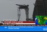
right now. north carolina's outer banks were struck especially hard. take a look at kill devil hills, a section of the fishing pier destroyed. severe flooding also a problem on low-lying areas of the coast. >> and sandy has done damage, even as far south as florida. take a look at this. part of a seawall was destroyed by the storm surge in this city here. this is on the east coast of florida. it's south of palm beach. >> you don't want to be below this scene up in new york. high winds from sandy knocking down this crane at a construction site in the big apple. it happened this afternoon in midtown at 57th street and 6th avenue. streets in that area were closed down, nearby buildings had to be evacuated. city officials there say there are no plans to go up and remove the crane right now. because it is just too dangerous. we heard earlier from bill kairns the winds are just howling up there in manhattan. doug kammerer has a new look at
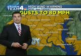
5:30 pm
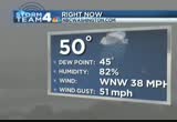
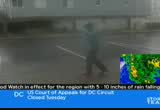
hurricane sandy at this hour. coug? doug? >> we show you this all the time. it gives great shots of the monuments across the area. a, you can't see a whole lot, and b, it's going in and out because of the winds down there at the airport. we'll show you what i'm talking about. temperatures at 50 degrees. look at the winds. sustained at 38 miles an hour. that is a sustained wind. very close to tropical storm force. our winds gusting to 51 miles an hour right now at the airport. we are really under the gun right now. we're going to continue to see these winds on the increase over the next few hours. that's why we continue to have the high wind warning in effect for the entire area until 8:00 tomorrow night. this will most likely be lifted tomorrow morning. at least shaved back. i expect the strongest winds between now and about 5:00 a.m. tomorrow morning. but could see stronger winds tomorrow afternoon, too. flood warnings, not just watches, but flood warnings, for every county in our viewing area. if you are watching us, you are under a flood warning.
5:31 pm
meaning you are currently seeing flooding, or flooding is imminent in your region, whether from a creek or river. you want to make sure you take precautions. we could see between five and ten inches of rain throughout. we've already seen nearly three inches at the airport. i think we're got another one to two inches at airport. some areas even more. we show the rain all across our region right now. watch what happens as the center moves inland just to our north. so does the heavy rain move inland, baltimore, gaithersburg, montgomery county, frederick. this is the area we could see the most rain. you see the heavy rain coming through the washington, d.c., area too. tomorrow, starting off at 6:00 a.m., we're still dealing with at least light rain. notice the snow back to the west in western portions of west maryland and west virginia. blizzard warnings there. i've seen between one to two to three feet of snow expected well to our west in the mountains. and tomorrow afternoon around 1:00, we're seeing a very cold afternoon. we will see scattered showers. and maybe even some snowflakes around parts of our region.
5:32 pm

best chance will be to the west as the storm system continues to move inland. we'll continue to watch it for you right here from the storm center. >> flooding a big concern for people around our area as conditions grow worse. >> we have several reports that there have been a number of road closures in fairfax county because of high water. northern virginia bureau chief julie carey is at one of those locations in anondale. >> reporter: i'm just the street from that location. that is woodburn road right there. you go down the hill there, and you've got no choice but to turn back around. take a look at the video. you'll see why. this is the creek that frequently floods when there is heavy rain. the water starts to rise. and you can see, it is flowing through there fiercely right now, carrying a lot of big pieces of trees along with it. in fact, when we were down there, getting the videotape, a
5:33 pm

tree came down, gave us a little bit of a jolt. we've seen a number of cars come down that road, flip and turn the other way. we saw the vdot truck come through. they've been busy. woodburn road, one of at least a dozen roads closed in fairfax county, most of them due to high water. a few with trees down, a few a case of power lines. they've got the heavy duty barricades there. so people definitely aren't trying to ford through those streams. julie carey, news4. >> thank you, julie. >> one of the largest communities. >> tom sherwood joins us live from the seventh street landing in the southwest with his story. hi, tom. >> reporter: you can see the boats out here. they're all tied down. the washington area has an extensive network of marinas.
5:34 pm

this is just one of them. there are about 400 boats and more than 100 what they call live-aboards. they're expecting more winds and high water tonight. like most of the marinas around here, they say they're prepared. >> yeah, we saw this coming. we've been prepping for this for about a week. not the first storm. and we've got crews here that go out and make sure the boats are properly tied. they are secured. this is a community like a family, so we watch out for each other and take care of each other's boats. >> is there anything different for the people with the live-aboards rather than the pleasure boats? >> not at all. but make sure you've got your water storage in case we lose water supply, or power. most of us have generators. even electricity is not a problem. >> reporter: i did talk to someone who lives at the gang plank marina, jason cop cop, and he admitted if the storm really kicks up tonight and gets really
5:35 pm

windy, he said it's hard to sleep on some of these boats. he said some people are checking into the channel inn which sa motel down here on the waterfront that's been here since the '60s. i just checked with him. there are a couple of rooms left. live on the waterfront, back to you guys. >> thank you, tom. >> and we are going to go now to -- we're going to ava marie in baltimore county. she is in ocean city right now. ava? >> reporter: we're just getting into the worst of the winds. funneling through the buildings right now straight out of the west. can you just see the incredible amount -- i don't know if you can see it through the camera right now, but it is driving the rain straight back to the ocean. the opposite scene from what we saw this morning when the rain was coming the opposite direction. the trees give you a bit of an indication how strong it's blowing as well. i have this fancy little weather station in my hand and it's recording a lot of different things for me. not only the temperatures, which
5:36 pm
are based only in the low 50s right now, it's reporting the windchill, which is already in the 40s when you factor in the gusts up to 60 miles an hour. not only are we getting drenched in rain, but it feels like it's in the 40s. such a different scene than a typical hurricane when you expect the warm rains. we are urging people to stay indoors. this is really a good reason why. i'm going to walk out a little bit further into the wind. we're under the safety of this little parking shelter here, so don't worry, i'm okay, i'm able to get back to shelter quickly. but the winds just get funneled through the buildings. you may have heard other meteorologists talking about it. it really funnels those winds quickly through a little corridor. that's the reason why you want to stay inside. reporting in ocean city where the winds continue to strengthen. the winds will just be stronger as the storm continues to move
5:37 pm

on. ava marie in ocean city. back to you guys. >> thanks, ava. >> when our sandy coverage continues, how one man's morning jog became a youtube sensation. >> and a look at the impact of the storm's wind and rain on other cities up and down the eastern seaboard.
5:38 pm

president obama: there's just no quit in america... and you're seeing that right now. over five million new jobs. exports up forty one percent. home values... rising. our auto industry... back.
5:39 pm

and our heroes are coming home. we're not there yet, but we've made real progress and the... last thing we should do is turn back now. here's my plan for the next four years: making education and training a national priority; building on our manufacturing boom; boosting american-made energy; reducing the deficits responsibly by cutting where... we can, and asking the wealthy to pay a little more. and ending the war in afghanistan, so we can... do some nation-building here at home. that's the right path. so read my plan, compare it to governor romney's... and decide which is better for you. it's an honor to be your president... and i'm asking for your vote... so together, we can keep moving america forward. i'm barack obama and i approve this message.
5:40 pm

we've got to show you this. th ere was a strange sight during megan mcgrath's live shot earlier today. she was reporting about conditions in the bloomingdale conditions in northeast washington, then she saw this. this guy, it was bad enough that he was only wearing shorts in the cold, wet rain. but what really got us was his mask. it's a horse mask. yes, a horse mask. the guy was walking up and down the street. he did that for a little while
5:41 pm

and he raised both his hands in triumph. ey, he's the winner. he won, we don't know what, but he won something. then he just trotd off. i guess halloween can't get here early enough for him. >> while our area braces for the worst of sandy, others are already coping with, yes, snow and some serious damage. >> news4's jim rosenfield is here with the story. >> pat and jim, those were odd images, the guy with the horse costume. but wait until you see this strange image. blizzard conditions coming along with this storm already hitting west virginia. take a look. pictures from snowshoe, west virginia. where up to three feet of snow could fall in the mountains. winter storm warnings are also in effect for parts of western maryland as well. to new jersey now, the normally busy atlantic city. it's become a ghosttown. wind gusts now topping 70 miles per hour. just north of there, look at this photo, waves crashing over
5:42 pm
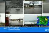
a seawall. mandatory evacuations in place by some parts of the state. look at the firefighters there. and this is what we're seeing in philadelphia. this is before sandy even makes landfall. high winds blowing this tree onto this house. the roof damaged. rain seeping into the home there. and here's a photo album tweeted by our nbc colleague al roker from martha's vineyard, with use of heavy wave action there, the water starting to push into parking lots as well as street flooding on parts of that new england island getaway. we'll be keeping an eye on all of the east coast for you. if you have friends and family along the eastern seaboard, this is just the beginning. back to you. >> sure is. thank you, jim. there is more breaking news tonight. immediate there is an immediate evacuation
5:43 pm

tonight in fairfax county. >> what is the latest on this massive storm right now? >> the very latest is that it's just about to make landfall in new jersey or delaware. we're watching this storm very closely. we will be here keeping you ahead of the storm. anncr: seven-hundred-thousand jobs. that's what the plan george allen supports... would cost our economy. newspapers called it "economically destructive." like allen's votes to give tax breaks to companies... that ship jobs overseas, his economic plan would...
5:44 pm

help big corporations, devastating the middle class. allen even voted against tax breaks for small businesses. virginia can't afford to go back to george allen. the democratic senatorial campaign committee... is responsible for the content of this advertising.

5:46 pm

the waterlogged soil combined with the high winds from sandy means trees, those trees are starting to come down. >> that's right. richard jordan was out and about this afternoon in northwest d.c. he continues our team coverage now, where a tree fell on a house today. richard? >> reporter: yeah, jim and pat, i just spoke briefly with the couple that lives inside the house. they were home when this tree came down on top of their roof. they're assuming it was a strong burst of wind that came by. but you can see the large tree from their backyard just fell on top of their home. it also clipped some of the other trees nearby. so other branches came down as well, even the neighbor's home suffered some roof damage. all this happening here, nevada and nebraska, the couple that lives inside, fortunately they were not hurt. they were able to go back into their home, escorted by d.c. emergency management workers. they went inside to grab a couple of their belongings, then they were sent over to their neighbor's home. that's where they're going to
5:47 pm

stay at least for the time being. the fire crews are out here, as well as police, just trying to assess the damage to the homes and see if there was any structural damage. they have since cleared the way. but it has been a pretty busy time for emergency workers in d.c. we've seen them just coming and going, with their si rememberen they respond to situations like this. power lines down, trees down. what's happening is, we're getting steady rain out here. right now, it's calm. but are little while, there will be a strong burst of wind that just kicks up. that seems to have been the issue here. what you're hearing from a lot of emergency management workers, if you have a two-story home and you have some large trees near you, where you feel they might be compromised with these strong winds, we're expecting, it's best to possibly if you can just sleep on the lower level, maybe in the living room and try not to be upstairs. if you have a situation like this, obviously that can be very serious. again, fortunately for the couple that lives here, they were not hurt.
5:48 pm
they're doing okay, just a little shaken up. >> richard, thanks. one of the longest lasting impacts of this storm for many will likely be the loss of electricity. >> jackie bensen is live along georgetown pike in mclean where crews were out working on the lines this evening. jackie? >> reporte >> reporter: we saw them do some heroic things. the dominion power contractors, i believe we have pictures of them with darkness approaching, and it's a dangerous job to begin with, they got in there, got up on those bucket trucks and they worked as fast as they could. but as safely as they could, to get power back after some trees came down and brought down power lines earlier this afternoon. again, it was literally a race against the clock to get georgetown pike open and get electricity back to a number of homes in this area. i want to quickly have my photographer turn around and show you, this is something you would not even notice on a
5:49 pm

normal day. but take a look at this. take a look at what the water's like. it's coming up over this driveway at this point. and i would say, if the rain continues like this, for the next two hours, for the next several hours, as doug kammerer was talking about, these areas in the mclean, tyson's area, they will flood right over and even more roads will be closed. so again, as it is getting dark, the best thing you can possibly do is stay home. reporting live, jackie bensen, news4. >> jackie, thanks. you get on one of those streets, you have old trees, dark roads, no power, that's a bad combination. let's get up-to-the-minute details on hurricane sandy, that is onshore right now. >> chief meteorologist doug kammerer has details about whether this is good or bad news, doug. >> yeah, close to making its way onshore as it makes its way close to cape may county, new jersey. we'll show you where the storm is right now, making its way inland. one thing you notice here, we're
5:50 pm
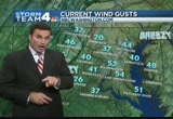
seeing dry air move in on the back side of this. so rain is cut off as the eye does move across portions of the inland. what we're also going to see, is this good news or bad news, this is neither. this is status quo. we're going to continue to see the winds, continue to see the heavy rain. here it is, here's the eye right in here. and you notice the northern part of the eye and northern portion of this storm, just going away, completely dry air moving in there. this is where the winds are. this is where the rain is. they are seeing 70-mile-an-hour wind gusts right now towards atlantic city, probably higher as that moves onshore. we are still seeing the heavy rain bands. every single one of these yellow bands that comes in, is going to continue to bring with it higher and higher gusts. we continue to see those through the 270 corridor, through the district, northwest, toward bethesda, gaithersburg, fairfax county, leesburg about to see another band going through there. you can see your winds on the increase. 51-mile-an-hour wind. that was the latest report out at reagan national airport.
5:51 pm
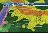
51 toward the patuxent river. and down farther, nearly 80 miles an hour. we're just getting into some of the strongest winds. we'll continue to see these strong winds throughout the rest of the evening. winds out of the west-northwest at 38 miles an hour, that's sustained, with the gusts over 50 miles an hour. as we move through the rest of the evening, we see this high wind warning in effect for gusts upwards of 80 miles an hour across the region. we will see those throughout the night tonight. most likely through about 1:00, 2:00, 3:00, 4:00, 5:00 in the morning. we'll see a lot of trees down from this. increasing winds, gusting 60 miles or more throughout the evening. a cold, windy rain. as we look for tomorrow morning, rain continues. not as heavy. we'll see river rises throughout the day. that's why we have all those flood warnings, the rivers, creeks, they continue to rise through early tomorrow morning.
5:52 pm

once again, if you don't have to be anywhere, government's shut down, schools are closed, you might not want to get out on the roadways. tomorrow afternoon, river rises once again and localized flooding. temperatures 44 to 47 degrees. winds out of the northwest at 20 to 30 miles an hour. we can't rule out a snowflake or two in parts of the area. the next couple of days, 54 degrees on your wednesday. 56 on thursday. right now, the weekend looking much better, and dry as we begin to clean up from sandy. >> all right. that looks much better. >> it does indeed. sandy and safety. how long food lasts after the power goes out. and what about your tap water? >> liz crenshaw is here with us to help keep us all out of the dark. >> we'll try to solve some of these problems. the big thing people worry about is how long will my food last. listen up. the usda reminds people to keep the doors of your fridge and your freezer closed. the refrigerator will keep food safely and cold for only about four hours. a full freezer, on the other hand, is going to hold the
5:53 pm
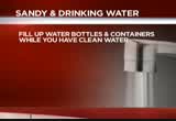
temperature for about two days. a half a freezer only about one day. now, when it comes to your drinking water, folks with a well, you know you're going to lose water because your well pump won't work. but water authorities tell us, residents on public water will most likely not lose water in the storm. but if there's a catastrophic power failure, that would cause the public water loss, or if a water main breaks in your area, it could cause a particular neighborhood to lose water. fema does recommend filling up water bottles, just in case, rinse out the bottles you were going to recycle today, and fill them with water. you can also fill up your bathtubs. use the bathtub water for cleaning purposes only or flushing your toilet. the bottom line is, folks, you have safe drinking water now if you still have water, fill up the bathtub. it will be an insurance policy. maybe we won't need it, but it would be nice if you do. >> four hours on the fridge? >> just four hours on the
5:54 pm

fridge. and that's if you keep the door closed. if the kids keep opening the door -- >> i'm getting hungry. clean out the fridge. >> thanks, liz. still to come, a dangerous situation after hurricane sandy announces her arrival in new york city. >> stay up to date with us on sandy all night long. you can also get updates 24/7 on nbcwashington.com. just search sandy. follow @nbc washington on twitter. sign up for newsalerts at nbcwashington.com back s


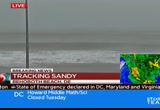
5:57 pm
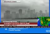
sandy is making her presence felt all up and down the east coast. and this is a picture sent to us from somebody in brooklyn. it shows the lower manhattan skyline. this is very ugly. it looks very gray and very ominous. >> like it's out of a movie. we have been everywhere here tonight, folks. michelle franzen is live in battery park with how conditions are there now. michelle? >> reporter: well, jim and pat, i can tell you, it is very ominous in realtime here, and getting worse by the hour. we're just getting into the real nuts and bolts of sandy here, as she gets ready to hit further south. and obviously we're on that very
5:58 pm
strong wind end. take a look at new york harbor here, this is where the hudson sort of flows to the south here on the southern tip of manhattan. this is one of the areas that's been evacuated, one of the low-lying areas in new york city, battery park, high tide this morning, we already saw those waves come over. and tonight, in a few hours, about 8:30, we're going to be tested once again. it's going to be a bigger test this time around. surges are expected anywhere between 6 and 12 feet. already we're told that low tide is already higher than normal. so we've got a long night ahead. not just with this surge, and getting through that time, but with the rain. we've been getting pelted with rain most of this day. it's supposed to continue well into tomorrow, or the next day. of course, we've got a precarious situation in midtown due to these wind gusts, up to 640 miles an hour. a crane collapsed off the top of a construction site there in the midtown area. and officials are just trying to
5:59 pm

secure the area around it. evacuate it. keep it safe. because it's too dang louse, they say, right now to try to secure that crane in any other way. it's just dangling from that point. a lot of issues that are taking place there. of course, the subway system's closed, the links, the bridges will close tonight, everyone hunkering down here in new york city. jim, pat? >> right now at 6:00, hurricane sandy is packing 50 to 60-mile-an-hour winds. and it's only going to get worse through the night. both airports are shut down. roads are closed. there's flooding everywhere. and the power outages are just beginning. the federal government and school districts are already closing for tomorrow. >> we have reporters all over the place tonight. i'm jim vance. >> i'm doreen gentzler.
319 Views
IN COLLECTIONS
WRC (NBC) Television Archive
  Television Archive News Search Service
Uploaded by TV Archive on
